Tuesday 21 July 2026 19:05:54 PHT


Anda
IJsselstein, Wednesday, 26 January 2011 (updated: Wednesday, 5 March 2014)
Anda is located on a small peninsula at the eastern tip of Bohol, 99 kilometers from Tagbilaran City. Due to distances from Tagbilaran, Anda is still not really a touristic destination although Anda has numerous nice places to be explore like beautiful diving spots, a peaceful and beautiful long stretch of white beaches, caves where some of them were used as a burial place of the ancient Andahanons.
History
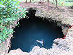 |
| Cabognaw Cave |
Originally, the municipality was a barangay of Guindulman called Quinali after to the characteristic land formations of sand, gravel and corals that filed layer after layer amassed by waves since time immemorial. The town was made into a separate municipality on March 12, 1875 and was renamed "Anda" which is said to mean walking and moving (to posterity). Others claim this name was chosen in honor of Simon de Anda y Salazar, who was the Spanish governor of the Philippines in 1769.
Highlights
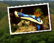
 |
| Lamanoc Island |
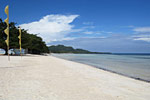
As already mentioned, Anda has some very nice long beaches. One can walk along this beach for some four kilometers, almost all the way from the boundary with Guindulman to the town center, which is facing the beach.
 |
| Anda |
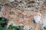
Behind the beaches, the coast is formed from lime-stone rocks and cliffs, often overhanging the beach and heavily eroded. When climbing those rocks, you need to observe utmost care, as they are very irregularly shaped and can be very sharp. Behind some of the cliffs, one can find caves, some of which have served as burial places for the local people in pre-hispanic times. (Unfortunately, some of these burial places have been pilfered by unscrupulous antique dealers, with the wooden coffins being offered for sale in Tagbilaran.)
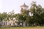 |
| Anda Church |
Further inland, one can find numerous impressive caves, some underwater. Be careful to only enter caves with an experienced guide who knows the local conditions!
 |
| Ceiling Murals in Anda Church |
In the town itself, you can find the parish church, dedicated to Santo Niño, which was completed in 1926. Although this church looks plain from the outside, it boasts some excellent ceiling paintings, by the well-known Cebuano artist Ray Francia, who decorated many of Bohol churches. Those in Anda are probably the best preserved, and well worth the trip to this remote place.
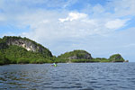 |
| Lamanoc Island |
 |
| Lamanoc Island |
What to do and see in Carmen: La manok tour, Cabognaw cave and white beaches.
Anda Municipal Office: +63 38 528 2009
Anda Police Station: +63 38 528 2009
Website: www.andabohol.gov.ph
| Anda at a glance | |
| Population (2015): | 16462 |
| Population (2010): | 16909 |
| Population (2000): | 17863 |
| Number of households (2000): | 3072 |
| Land area: | 6110 ha |
| Number of barangays: | 16 |
| Distance from Tagbilaran: | 99 km |
| Barangay | Population (2000) | Households (2000) | Population (2010) | Population (2015) |
| Almaria | 386 | 73 | 392 | 370 |
| Bacong | 2058 | 402 | 2289 | 2323 |
| Badiang | 1817 | 241 | 1277 | 1281 |
| Buenasuerte | 478 | 70 | 398 | 321 |
| Candabong | 2164 | 369 | 2297 | 2193 |
| Casica | 462 | 86 | 406 | 464 |
| Katipunan | 684 | 102 | 503 | 467 |
| Linawan | 1105 | 184 | 987 | 918 |
| Lundag | 1087 | 165 | 1029 | 980 |
| Poblacion | 1286 | 247 | 1295 | 1312 |
| Santa Cruz | 1151 | 188 | 1123 | 1073 |
| Suba | 1215 | 228 | 1125 | 1102 |
| Talisay | 1135 | 205 | 1048 | 936 |
| Tanod | 643 | 102 | 487 | 421 |
| Tawid | 785 | 154 | 825 | 789 |
| Virgen | 1407 | 256 | 1428 | 1512 |
(Based on figures from the census of 2000, 2010, and 2015 from PSA)
Links
Jeroen Hellingman
What readers think...
| Lougie wrote: |
| Friday, 29 December 2017 08:15:29 PHT |
| Hello, I'm a bit disappointed with the state of a anda right now. Everywhere you look there are trash. Please assign someone to clean it 2-3 times a day. Thank you. |
| michael wrote: |
| Saturday, 14 November 2015 02:36:33 PHT |
| I love Anda, I love it so much I bought some rural cheap agricultural land. i hope it always stays this way & does not get spoilt by over tourism that brings alcohol & drug issues, litter/rubbish/infestation, noise, pollution & generally spoils what Anda is. |
| Linda V.Simacio wrote: |
| Friday, 24 May 2013 00:32:08 PHT |
| I woud only like to give a comment to the famous governor in anda bohol to miss or mrs angelina simacio bisaya iam proudly to say to those thing and plesure that the people may it given in to u as a governor ur such a lucky person who woud love to grab the oppurtunity like that but i hope u can do make it right ive always seen ur names everytime .thats y this may simple comment to u may it help u inspired into ur dutys me as a simple person who is actually intersted in u i hope u gonna send me an message into my y.m iam sorry i hope u dont mind or in my cellphone no. 09399469274. my smart no bt iam linda valliente simacio were same last name and if iam not wrong b.stands for bisaya.or maybe iam wrong and also iam living in iligan city iam just only glad and happy to u of what youve have into ur life now ur lucky enough. |
Also give your comments on this article
We reserve the right to remove or edit comments posted on this website. Please read our conditions of use for details. You can use <i>italics</i>, <b>bold</b>, <p> new paragraph, <a href="url">link</a>. Other markup will be removed. Use of the forums for advertising is prohibited. Enterprises located in Bohol can request to be added to the business directory.

© 2001-2017 Jeroen Hellingman, all rights reserved. [page served to 216.73.216.189 in United States]