IJsselstein, Saturday, 14 January 2012 22:58:38
Jetafe (sometimes also spelled Getafe) is a port town on the northern coast, 92 kilometers from the capital.
|
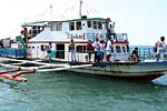
| Outrigger Ferry |
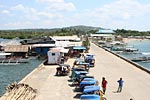 |
| Getafe Pier |
Jetafe Police Station: +63 38 514 9052
Bank: First Consolidated Bank "FCB"
| Jetafe at a glance | |
| Population (2015): | 30955 |
| Population (2010): | 31789 |
| Population (2000): | 26826 |
| Number of households (2000): | 4694 |
| Land area: | 9980 ha |
| Number of barangays: | 24 |
| Distance from Tagbilaran: | 92 km |
| Barangay | Population (2000) | Households (2000) | Population (2010) | Population (2015) |
| Alumar | 669 | 120 | 935 | 1164 |
| Banacon | 1391 | 260 | 1304 | 1298 |
| Buyog | 709 | 124 | 775 | 906 |
| Cabasakan | 1134 | 194 | 1149 | 1179 |
| Campao Occidental | 415 | 58 | 418 | 484 |
| Campao Oriental | 951 | 158 | 963 | 1034 |
| Cangmundo | 1008 | 162 | 968 | 972 |
| Carlos P. Garcia | 755 | 142 | 858 | 994 |
| Corte Baud | 692 | 115 | 704 | 868 |
| Handumon | 927 | 162 | 983 | 1172 |
| Jagoliao | 1626 | 263 | 1478 | 1353 |
| Jandayan Norte | 876 | 157 | 901 | 963 |
| Jandayan Sur | 1657 | 267 | 1360 | 1538 |
| Mahanay (Mahanay Island) | 433 | 65 | 484 | 538 |
| Nasingin | 1666 | 317 | 1809 | 2045 |
| Pandanon | 1947 | 348 | 1840 | 2228 |
| Poblacion | 2092 | 406 | 2371 | 2695 |
| Saguise | 1303 | 238 | 1358 | 1652 |
| Salog | 1071 | 180 | 1036 | 1195 |
| San Jose | 1413 | 238 | 1432 | 1729 |
| Santo Nińo | 631 | 100 | 686 | 768 |
| Taytay | 1082 | 204 | 1334 | 1536 |
| Tugas | 855 | 148 | 896 | 886 |
| Tulang | 1523 | 268 | 1746 | 1758 |
(Based on figures from the census of 2000, 2010, and 2015 from PSA)
Jeroen Hellingman